Syria is presented to world through Western main stream media as if Syrians are Jews not Arabs....and Israel is presented to world as someone who does its best to protect Syria from Turkish invasion while already engaging in swift ethnic cleansing even through theft of Syrian water resources. Netanyahus throws on table the so caled Greater Israeli HISTORIC map on which all the rivers and lakes belong to Israel. Turkey is a NATO ember state - Israel is only was/is recipinet of NATO aid since one appeared on the map. And Turkey is not Iran - Turkey was ally with NATO in case of Iran.
Water theft persists as Israel
grabs 40 percent of Syria's vital water resourcesFor years, the Israeli regime coveted Syria’s abundant water resources, particularly in the country’s southern regions, to mitigate its own chronic water shortages.
After the dramatic fall of Bashar al-Assad’s government in Damascus last month, Tel Aviv unleashed an aggressive and unprecedented military assault on Syria with multiple strategic objectives.
Israeli forces swiftly expanded beyond the occupied Golan Heights, seizing the buffer zone and Mount Hermon—a pivotal peak that straddles the borders of Syria, Lebanon, and Palestine.
Yet this incursion was only the beginning. On Thursday, Syrian media reported that Israeli occupation forces captured the Al-Mantara Dam, the lifeline for Quneitra and its surrounding areas.
It came as they bombed the headquarters of the Syrian Army’s 90th Brigade in Sasa, near Damascus, as a cover-up for their latest theft.
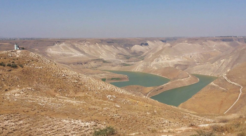
Located just a few hundred meters east of Quneitra, some 50 kilometers southwest of the Syrian capital, Al-Mantara Dam sits within the buffer zone established on the Golan Heights in 1979.
This vital water reservoir has for long sustained not only Quneitra province, where the occupied Holan Heights is located, but also the broader arid southern region of Syria.
With the occupation of Al-Mantara Dam, the most significant dam in southern Syria, experts say nearly 40 percent of Syria's water resources are now under the illegal control of the Israeli regime.
Before Al-Mantara, they occupied five other key sites that supply water to Syria from neighbors.
The city of Quneitra and its surrounding areas fell to Israeli forces in December, days after Assad’s government collapsed and West-backed militants, led by Hayat Tahrir al-Sham, seized control.
In rapid succession, the Tel Aviv regime occupied 266 square kilometers of buffer zone territory, flagrantly violating the 1974 Agreement on Disengagement. Israeli occupation forces then pushed further east, confiscating additional Syrian territory illegally.

The occupation zone now stretches from the eastern slopes of Mount Hermon on the Lebanese border to the Yarmuk River valley near Jordan in the south.
After advancing into the region, Israeli troops established military checkpoints, erected earthen barriers, and imposed strict entry and exit controls, upending the daily lives of local residents.
Angered by these disruptions, Syrians across occupied settlements staged widespread protests. Israeli forces responded with live fire, further stoking tensions and outrage.
The so-called "safe zone" narrative invoked grim memories of previous occupations in Lebanon, the Golan, and Palestine—territories that the Zionist regime dominated for decades and still seeks to annex and control.
Occupied dams and rivers
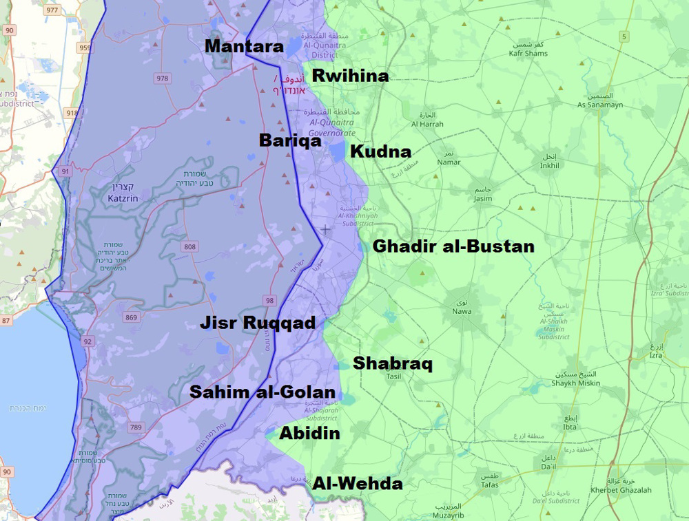
A closer look at the borders of the Israeli occupation zone in Syria reveals that the focus was on capturing all the vital reservoirs and rivers in the occupied Golan Heights.
In addition to the 3.5 km long Al-Mantara embankment dam, located within the UN buffer zone, nine other dams outside the zone were also captured, all in the Quneitra and Dara'a provinces of Syria.
The Israeli occupation army also occupied the smaller Rwihina Dam, located 2.5 km downstream on the same Ruqqad River, otherwise the natural border of the Golan Heights to the east.
On the same river, another ten kilometers downstream, there is the 3-kilometer-long Kudna Dam, occupied together with the nearby smaller Bariqa Dam.
Two other relatively larger occupied dams on the Ruqqad River are the Ghadir al-Bustan Dam near the settlements of Zaghbi and Nasiriya, and the Jisr Ruqqad Dam near Saida and Ain Zakar.

The Ruqqad River, as one of the most important tributaries, flows downstream into the Yarmuk River, the natural border between Syria and Jordan, and the latter further into the strategically and water-bearing equally important Jordan River.
Three other occupied dams, located to the east on tributaries of the Ruqqad River, are Shabraq Dam, Sahim al-Golan Dam, and Abidin Dam.
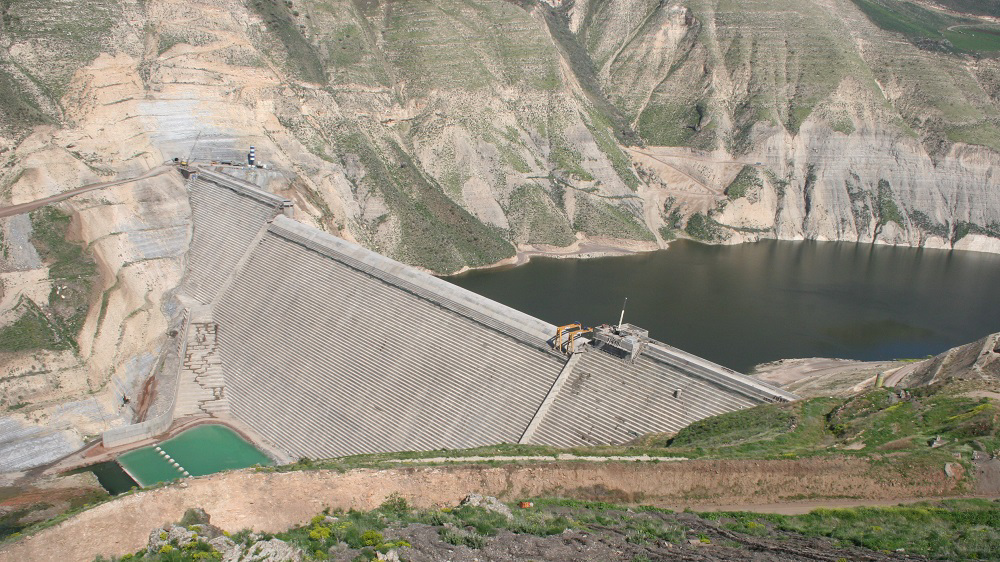
The tenth occupied reservoir is at Al-Wehda (Maqarin) Dam, a 110-meter-high concrete gravity dam on the Yarmuk River, on the border between Syria and Jordan.
Joint Jordanian-Syrian plans for this dam have existed since the early 1950s, but it only opened in 2011, the year Syria saw the eruption of foreign-backed militancy.
The biggest opponent of the dam's construction was the Israeli regime, claiming that the reservoir would threaten the supply of the Jordan River, on which it depends for drinking water and has repeatedly gone to war with its neighbors over it.
Besides these dams, in the north of the occupied zone, next to Mount Hermon, the Israeli army occupied the valley of the Awaj River, which together with the Barada River represents the key feeder of the basin of Damascus province.
A land without water
The Israeli occupation of the aforementioned reservoirs and rivers represents a significant blow to the HTS authorities, considering that it is the latest in a series of foreign restrictions on water access.
The loss of nine relatively low embankment dams with shallow reservoirs and one high dam does not seem like much compared to the figures of over 150 dams across the country and over 15 cubic kilometers of water brought annually by the mighty Euphrates.
However, the problems with the Euphrates are multiple because it is controlled by the US-controlled Kurdish autonomy, Turkey often deliberately prevents normal flow with its dams, and almost 60 percent of the river's waters are secured to downstream Iraq through agreements.

The multibillion-dollar water transfer project from the Euphrates to Damascus began with plans in this century and was never fully realized.
The water level of the Euphrates, on which 90 percent of the country's water supply and 70 percent of its electricity depend, was at a record low in 2021 and led to catastrophic problems across the country, including hours-long power cuts in the capital.
In recent years, 7 million people from Damascus and southern Syria have relied mainly on local smaller rivers, specifically the Awaj, Barada, Ruqqad and Yarmuk, as well as groundwater.
Among them, the first three rivers individually have an annual discharge of no more than 100 million cubic meters per year, the Yarmuk (shared with Jordan) about half a billion, while the local demand is over a billion.
With the loss of the lower Yarmuk Valley, the upper Awaj Valley, as well as most of Ruqqad River, 90 percent of the capital area's supply will now be at the mercy of the occupying Israeli regime.
Zionist water policy
For Tel Aviv, the occupation of Syrian water resources is not only a useful political tool for blackmailing the HTS authorities in Damascus but also a valuable natural resource that they do not have.
Water resources have been a focus of the Zionist regime since before the establishment of their entity in occupied Palestine and during successive wars against Arab neighbors.
Chaim Weizmann, one of the Zionist forefathers and the entity's first president, at the Paris Peace Conference in 1919 demanded that the boundaries of any future state should include the headwaters of the Jordan (Mount Hermon) and the lower reaches of the Litani River (Lebanon).

According to Weizmann, the control of the Litani, Jordan and Yarmuk rivers, which was expressed in a letter to the British Prime Minister, was very much central to the future Zionist entity's security.
David Ben-Gurion, another key Zionist founder and the entity's first prime minister, in 1948 similarly reiterated that their boundaries include the southern banks of the Litani River, but the League of Nations rejected these claims to Lebanese territory
The post-war consensus is that Lake Tiberias, the Jordan River, and the Litani River have been Israeli targets in numerous wars from 1948 to the present, including last year's attempts to break out onto the banks of the latter Lebanese river.
The Zionist entity today receives about 80 percent of its water supply through five key desalination plants, located next to coastal power plants.
However, these facilities are large in surface area and fragile in a potential conflict, especially with ballistic missile strikes, that could leave millions of settlers without access to water.
Hence, the Israeli regime continues to resort to old plans to occupy foreign water-rich territories, which is being witnessed in Syria currently.
Abulmalik al-Houthi, leader of the Yemeni Ansarullah resistance movement, in his speech on Saturday, also pointed to the fact that Israeli aggression in Syria aims to seize control of water resources.


No comments:
Post a Comment